
File:Map Portuguese World.png

預覽大小:800 × 384 像素。 其他解析度:320 × 154 像素 | 640 × 308 像素 | 1,357 × 652 像素。
原始檔案 (1,357 × 652 像素,檔案大小:36 KB,MIME 類型:image/png)

摘要
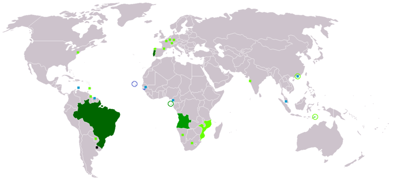
Portuguese linguistic sphere today. Map made from Image:BlankMap-World.png
Legenda em Português:
- Preto: Não oficial mas obrigatório no sistema público de ensino;
- Verde-escuro: Língua materna;
- Verde: Língua administrativa;
- Verde-claro: Língua secundária ou não oficial;
- Quadrado verde: Minorias falantes de português;
- Azul: Crioulo de base portuguesa;
- Quadrado azul-claro: Minorias falantes de crioulo de base portuguesa.
Legend in English:
- Black: Not official but obligatory in public educational system
- Dark green: Native language
- Green: Administrative language
- Light green: Secondary language or non-official
- Green square: Portuguese speaking minorities
- Blue: Portuguese-based Creole
- Light blue square: Portuguese-based Creole speaking minorities
Français : Carte du monde où on parle le portugais
- Noir : non oficiel, mais obligatoire dans le système d'éducation public
- Vert foncé: langue maternelle
- Vert: langue administrative
- Vert clair : langue importante et/ou langue de culture
- Carré vert: minoritées parlant le portugais
- Bleu: créole de base portugais e
- Carré bleu clair: minoritées parlant créole de base portugaise
Deutsch: Weltkarte mit portugiesischsprachigen Gebieten
- Schwarz: Nicht offiziell, aber obligatorisch im Bildungssystem verankert
- Dunkelgrün: Muttersprache
- Grün: Amtssprache
- Hellgrün: Wichtige (Verkehrs-)sprache und/oder Kultursprache
- Grünes Quadrat: Portugiesischsprachige Minderheiten
- Blau: Portugiesischbasierte Kreolsprache
- Hellblaues Quadrat: Minderheiten portugiesischbasierter Kreolsprache
Italiano: Legenda:
- Nero: Non ufficiale, ma obbligatoria nel sistema di istruzione pubblico
- Verde scuro: Lingua materna
- Verde: Lingua amministrativa
- Verde chiaro: Seconda lingua o lingua non ufficiale
- Quadrati verdi: Minoranze portoghesi
- Blu: Creolo portoghese
- Quadrati celesti: Minoranze creolo portoghesi
한국어: 범례:
- 검은색: 공용어는 아니지만 공교육 체계에서 의무인 지역
- 진한 녹색: 모국어로써 사용하는 지역
- 녹색: 공용어로 지정한 지역
- 연두색: 제2언어 혹은 비공식 언어인 지역
- 녹색 사각형: 포르투갈어 소수 사용 지역
- 밝은 파란색: 포르투갈어 기반의 크레올어가 사용되는 지역
- 밝은 파란색 사각형: 포르투갈어 기반의 크레올어가 소수 사용되는 지역
日本語: 使用域:
- 黒: 公用語ではないが、公教育での習得が義務とされている
- 深緑: 母語
- 緑: 公用語
- 黄緑: 公用語ではないが、主要言語の1つとして使用される地域
- 緑の四角: 話者の少数派コミュニティのある地域
- 水色: ポルトガル語のクレオール言語が使用されている地域
- 水色の四角: ポルトガル語のクレオール言語話者の少数派コミュニティのある地域
User: Dom Aleixo (Emerson)
授權條款
Ilario,此作品的版權所有人,決定用以下授權條款發佈本作品:
| 我,此作品的版權所有人,釋出此作品至公共領域。此授權條款在全世界均適用。 這可能在某些國家不合法,如果是的話: 我授予任何人有權利使用此作品於任何用途,除受法律約束外,不受任何限制。 |
檔案歷史
點選日期/時間以檢視該時間的檔案版本。
| 日期/時間 | 縮圖 | 尺寸 | 用戶 | 備註 | |
|---|---|---|---|---|---|
| 目前 | 2018年3月7日 (三) 22:02 | | 1,357 × 652(36 KB) | Maphobbyist | Montenegro and South Sudan borders |
| 2008年1月27日 (日) 05:44 |  | 1,357 × 652(47 KB) | Domaleixo | Portuguese linguistic sphere today. Map made from Image:BlankMap-World.png English: Legend: * Black: not official but obligatory in public educational system * Dark green: native language * Green: administrative language * Light green: S | |
| 2006年1月18日 (三) 10:38 |  | 1,357 × 628(30 KB) | Ilario | Map made from Image:BlankMap-World.png {{PD-user|Yug}} {{en|Legend: *Dark green: native language *Green: administrative language *Light green: Secondary language or non-official. *green square: portuguese minorities *light blue: Creole portuguese *l |
檔案用途
沒有使用此檔案的頁面。
全域檔案使用狀況
以下其他 wiki 使用了這個檔案:
- de.wikipedia.org 的使用狀況