
File:Map of Argentina with provinces.svg

此 SVG 檔案的 PNG 預覽的大小:363 × 599 像素。 其他解析度:145 × 240 像素 | 291 × 480 像素 | 465 × 768 像素 | 621 × 1,024 像素 | 1,241 × 2,048 像素 | 568 × 937 像素。
原始檔案 (SVG 檔案,表面大小:568 × 937 像素,檔案大小:466 KB)
摘要
| 描述 |
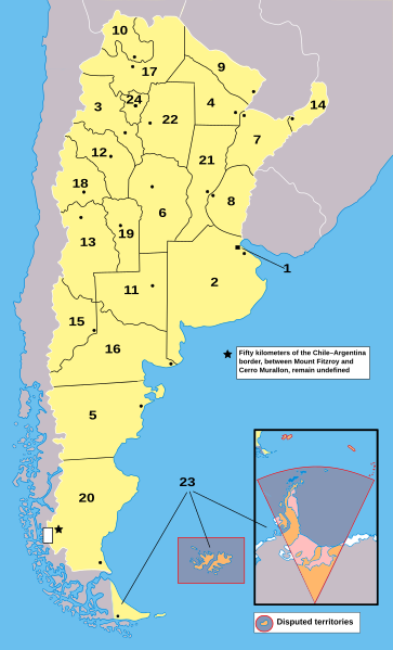
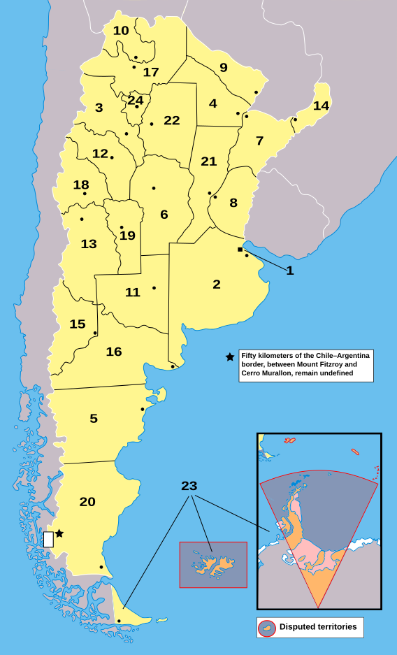
English: Map of Argentina with provinces. Provinces are numbered according to Argentina#Provinces
Català: Mapa de les províncies de l'Argentina. Els territoris en taronja no estan sota sobirania argentina: estan sota sobirania del Regne Unit (per exemple, les Illes de l'Atlàntic Sud) o és una reivindicació pendent (per exemple, l'Antàrtida).
1: Ciutat Autònoma de Buenos Aires 2: Província de Buenos Aires 3: Catamarca 4: Chaco 5: Chubut 6: Córdoba 7: Corrientes 8: Entre Ríos 9: Formosa 10: Jujuy 11: La Pampa 12: La Rioja 13: Mendoza 14: Misiones 15: Neuquén 16: Rio Negro 17: Salta 18: San Juan 19: San Luis 20: Santa Cruz 21: Santa Fe 22: Santiago del Estero 23: Terra del Foc, Antàrtida i Illes de l'Atlàntic Sud 24: Tucumán |
| 來源 | My own work based on public domain File:Argentina_-_Político_2.png. |
| 作者 | Lo2u (T • C) |
| 其他版本 |
|
| SVG開發 |


授權條款
| 我,此作品的版權所有人,釋出此作品至公共領域。此授權條款在全世界均適用。 這可能在某些國家不合法,如果是的話: 我授予任何人有權利使用此作品於任何用途,除受法律約束外,不受任何限制。 |
檔案歷史
點選日期/時間以檢視該時間的檔案版本。
| 日期/時間 | 縮圖 | 尺寸 | 用戶 | 備註 | |
|---|---|---|---|---|---|
| 目前 | 2023年9月17日 (日) 09:39 | | 568 × 937(466 KB) | Editantpv | File uploaded using svgtranslate tool (https://svgtranslate.toolforge.org/). Added translation for ca. |
| 2008年10月24日 (五) 00:28 |  | 568 × 937(467 KB) | Lo2u | (({{Information |Description=Map of Argentina |Source=My own work based on public domain Image:Argentina - Político 2.png. |Date= |Author=Lo2u <sup>(T • C)</sup> |other_versions=Image:Argentina_-_Pol%C3%ADtico_2.png }})) | |
| 2008年10月24日 (五) 00:22 |  | 568 × 937(467 KB) | Lo2u | ({{Information |Description=Map of Argentina |Source=My own work based on public domain Image:Argentina - Político 2.png. |Date= |Author=Lo2u <sup>(T • C)</sup> |other_versions=Image:Argentina_-_Pol%C3%ADtico_2.png }}) | |
| 2008年10月22日 (三) 22:26 |  | 568 × 937(468 KB) | Lo2u | {{Information |Description=Map of Argentina |Source=My own work based on public domain Image:Argentina - Político 2.png. |Date= |Author=Lo2u <sup>(T • C)</sup> |other_versions=Image:Argent | |
| 2008年10月22日 (三) 22:20 |  | 568 × 937(468 KB) | Lo2u | {{Information |Description=Map of Argentina |Source=My own work based on public domain Image:Argentina - Político 2.png. |Date= |Author=Lo2u <sup>(T • C)</sup> |other_versions=Image:Argent | |
| 2008年10月22日 (三) 20:30 |  | 568 × 937(562 KB) | Lo2u | {{Information |Description= |Source=My own work based on public domain Image:Argentina - Político 2.png. |Date= |Author=~~~ |other_versions=Image:Argentina_-_Pol%C3%ADtico_2.png }} |
檔案用途
下列頁面有用到此檔案:
全域檔案使用狀況
以下其他 wiki 使用了這個檔案:
- bn.wikibooks.org 的使用狀況
- bo.wikipedia.org 的使用狀況
- br.wikipedia.org 的使用狀況
- ca.wikipedia.org 的使用狀況
- en.wikibooks.org 的使用狀況
- es.wikipedia.org 的使用狀況
- fur.wikipedia.org 的使用狀況
- fy.wikipedia.org 的使用狀況
- he.wikipedia.org 的使用狀況
- id.wikibooks.org 的使用狀況
- ja.wikipedia.org 的使用狀況
- la.wikipedia.org 的使用狀況
- ru.wikipedia.org 的使用狀況
- tr.wikipedia.org 的使用狀況