
File:ChiPitts area.png
没有更高的分辨率。
ChiPitts_area.png (300 × 300像素,文件大小:23 KB,MIME类型:image/png)
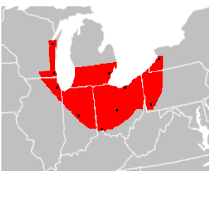
| 描述 | en:ChiPitts (Chicago-Pittsburg) megalopolis area in red. Major cities are shown with a black dot |
| 来源 | Image made from BlankMap-USA-states.PNG, modified to show approximate boundaries of the ChiPitts |
| 作者 | Ctjf83 |
| 其他版本 | en:Image:ChiPitts_area.png |
| |
本作品已被作者中文维基百科项目的Ctjf83释出到公有领域。这适用于全世界。 如果这样做不合法的话: |
文件历史
点击某个日期/时间查看对应时刻的文件。
| 日期/时间 | 缩略图 | 大小 | 用户 | 备注 | |
|---|---|---|---|---|---|
| 当前 | 2008年3月14日 (五) 14:27 | | 300 × 300(23 KB) | Pierre cb | {{Information |Description=en:ChiPitts megalopolis area in red. Major cities are shown with a black dot |Source=Image made from [http://commons.wikimedia.org/wiki/Image:BlankMap-USA-states.PNG BlankMap-USA-states.PNG], modified to show approximate b |
文件用途
以下页面使用本文件:
全域文件用途
以下其他wiki使用此文件:
- ca.wikipedia.org上的用途
- cs.wikipedia.org上的用途
- de.wikipedia.org上的用途
- eo.wikipedia.org上的用途
- fr.wikipedia.org上的用途
- mk.wikipedia.org上的用途
- pt.wikipedia.org上的用途
- uk.wikipedia.org上的用途
- www.wikidata.org上的用途